Walk onto any major UK construction or renovation site today, and chances are you’ll spot a tripod-mounted device scanning the building while everyone else gets on with the work. That’s a 3D laser scanner, and it’s quietly changing the way architects, surveyors, and engineers do their jobs. For decades, site surveys meant tape measures, clipboards, and a lot of squinting. Today, 3D laser scanning in architecture replaces all of that with a device that can record millions of precise measurements in the time it would take a surveyor to measure a single room. The results are more accurate, the process is faster, and the data can feed directly into the digital tools that modern design teams actually use. Here’s a proper look at how it works and why more UK architectural practices are using it.
What Is 3D Laser Scanning?
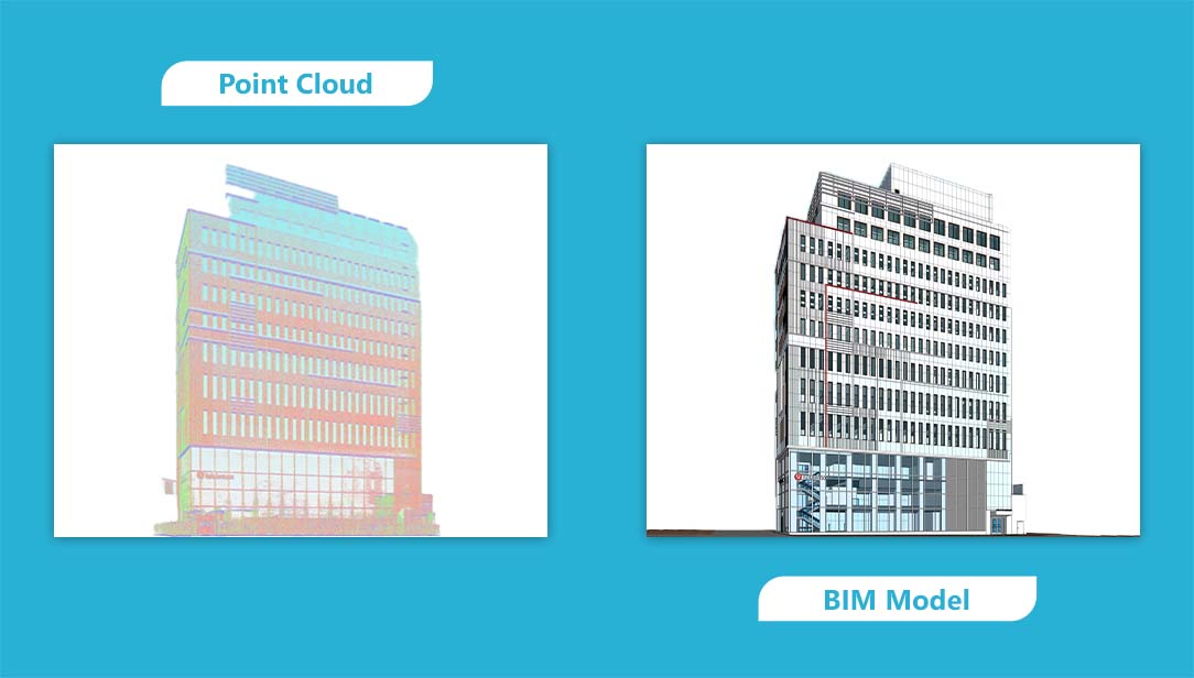
At its core, 3D laser scanning is a way of capturing the exact shape and dimensions of a building or space in digital form. The scanner fires laser pulses at surrounding surfaces and records how long each pulse takes to bounce back. Do that millions of times in every direction, and you end up with a dense cloud of precise spatial measurements, a point cloud that describes the geometry of the whole environment in three dimensions. It sounds complicated, but the output is actually very practical. Think of it as a photograph of a space, except instead of capturing colour and light, it captures precise measurements down to the millimetre.
How Does It Actually Work?
The scanner sits on a tripod and rotates slowly, firing laser beams in all directions. Each beam that hits a surface returns a measurement of the distance to that surface, plus the angle. Combine all those measurements, and you have a three-dimensional picture of the entire space. Survey teams usually take multiple scans from different positions across a site, inside rooms, along facades, and in roof spaces. Registration software then stitches all those individual scans together into one unified dataset. The final result gets exported in formats that modelling software can read, ready for the next stage of work.
Why It Matters for Architectural Projects
The value of laser scanning for architectural projects is straightforward: you get a record of exactly how a building looks right now. That matters enormously when you’re planning a renovation, extending an existing structure, or trying to understand why something doesn’t line up the way the old drawings said it should. Columns that have shifted, slabs that have dropped, facades that have bowed a laser scan catches all of it. Manual surveys often miss these kinds of discrepancies or catch them too late. It also means architects, engineers, and contractors are all working from the same verified dataset rather than different sets of assumptions.
The Different Types of Laser Scanners
The types of 3D laser scanners for BIM vary depending on the scale and complexity of the project. Terrestrial scanners are the most common in architectural work. They mount on a tripod, capture extremely dense data, and are ideal for interiors, facades, and structural elements. These are the workhorses of most building surveys. Mobile scanners are worn in a backpack or mounted on a cart. Operators walk through large facilities while the scanner records the space continuously. These are useful for large buildings, corridors, and industrial sites where terrestrial scanning would take too long. Aerial scanners use drones fitted with LiDAR equipment to survey rooftops, towers, and large sites from above. These are particularly useful when access is difficult or restricted. The choice of scanner comes down to the project: a Grade II listed townhouse needs a different kit than a distribution warehouse or a cathedral roof.
Key Benefits for Modern Architecture
The practical benefits of 3D laser scanning in architecture are fairly consistent across different project types. Surveys are faster and more comprehensive than traditional methods. Hidden utilities, structural quirks, and surface irregularities all show up in the data. Architects can extract floor plans, elevations, and sections directly from the point cloud without returning to the site. And because the dataset is shared, everyone on the project, like architects, structural engineers, and MEP consultants, works from the same reference point. For projects with tight tolerances or complex geometry, that kind of accuracy is not a luxury. It’s essential.
Applications in Design and Renovation
Laser scanning has become particularly useful where existing buildings are involved. When extending an old building, scan data lets design teams test how new work will connect with the existing structure before anything gets built. Interior designers use it to map ceiling voids, wall penetrations, and structural framing, the things you need to know before you can finalise fit-out layouts. MEPF-mechanical, electrical, plumbing, and fire Safety engineers use scan data to plan routes for new services around what’s already there. And facilities teams are increasingly using scan datasets to build digital twins of their buildings. This helps with maintenance planning and long-term operational management.
Documenting Historic Buildings
This is where 3D laser scanning really earns its place. Historic buildings across the UK, such as churches, country houses, and Victorian civic buildings, often have no accurate drawings or drawings that no longer reflect what’s actually there after centuries of alteration. Laser scanning captures carved stonework, vaulted ceilings, curved staircases, and irregular facades with a level of detail that photography and hand measurement simply cannot match. Conservation architects use the resulting data to study structural movement, plan restoration work, and create permanent digital archives. For buildings that are at risk, that archive may be the most important record that exists.
The Challenges Worth Knowing About
It’s worth being honest about the limitations. Highly accurate terrestrial laser scanning equipment is expensive, and the processing software that handles large datasets needs serious computing power. The datasets themselves are enormous; a detailed building survey can run to billions of individual measurements. There’s also a skills dimension. Getting clean, usable data from a laser scan requires trained operators who understand how to position the scanner, manage reflective surfaces, and prepare the output for use in modelling environments. A poorly executed scan can be almost as problematic as no scan at all.
How It Connects to BIM Workflows
The connection between laser scanning and Building Information Modelling is where the real value gets unlocked. Laser scan to BIM services take the raw point cloud data and use it to build structured BIM models. The kind that can be used for design coordination, construction planning, and facility management. In practice, this means importing the scan data into software like Autodesk Revit, using the point cloud as a spatial reference, and modelling walls, floors, columns, and facade elements from the actual geometry rather than from assumptions. The resulting models support clash detection, design validation, and all the coordination work that complex projects require.
Where the Technology Is Heading
Artificial intelligence is starting to accelerate the processing side of things. Machine learning tools can now identify building components such as walls, doors, pipes, and structural frames within a point cloud and model them automatically, rather than requiring a technician to trace everything by hand. Mobile and aerial scanning platforms are also making the technology more accessible for larger sites and infrastructure projects. And handheld scanners are lighter, cheaper, and increasingly capable. These are bringing basic spatial capture within reach of smaller practices and contractors. The direction of travel is clear. Faster capture, smarter processing, and wider adoption across the industry, with laser scanning in the construction industry becoming less of a specialist service and more of a standard part of how buildings get documented and delivered.